


The Inland Empire
Images and text from the Center for Land Use Interpretation:
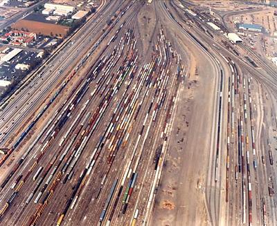
"The Inland Empire is a semi-urbanized region east of the Los Angeles basin. As large in area as the developed L.A. and Orange County regions combined, and bounded by mountain ranges, it has evolved into a sort of alternative version of Los Angeles, both separate from and connected to the [megalopolis].

Here are the steel mills, smokestacks, and racetracks of Fontana; the cement pits and piles of Rubidoux and Colton; the quarries of Temescal Valley; and the reservoirs of Perris, Matthews, and Diamond, massive elevated pools, looming above ground level.

Sacrificial sites like debris basins, flood channels, and huge canyon dams control the cataclysmic erosional dynamics caused by mountains of unconsolidated material faced with only occasional rainfall. Big, monolithic land uses abound between the freeways and washes – malls, railyards, airports, business parks, and military bases.

Housing occurs in swaths of units, on land recontoured into ranges of engineered escarpments of drainage vectors. And a frequent haze obscures the mountains that contain the region, giving a sense of a vague infinity to this landscape of moved earth."

If you can give money to only one organization this year, give it to the Center for Land Use Interpretation; these people kick your ass. I've seen Matthew Coolidge, the director, give talks twice, at Princeton and at Penn (the Princeton one was better), and he's friendly, funny, and looks like a carpenter from Ohio; and he's a genius.
"The Inland Empire is a semi-urbanized region east of the Los Angeles basin. As large in area as the developed L.A. and Orange County regions combined, and bounded by mountain ranges, it has evolved into a sort of alternative version of Los Angeles, both separate from and connected to the [megalopolis].
Here are the steel mills, smokestacks, and racetracks of Fontana; the cement pits and piles of Rubidoux and Colton; the quarries of Temescal Valley; and the reservoirs of Perris, Matthews, and Diamond, massive elevated pools, looming above ground level.
Sacrificial sites like debris basins, flood channels, and huge canyon dams control the cataclysmic erosional dynamics caused by mountains of unconsolidated material faced with only occasional rainfall. Big, monolithic land uses abound between the freeways and washes – malls, railyards, airports, business parks, and military bases.
Housing occurs in swaths of units, on land recontoured into ranges of engineered escarpments of drainage vectors. And a frequent haze obscures the mountains that contain the region, giving a sense of a vague infinity to this landscape of moved earth."
If you can give money to only one organization this year, give it to the Center for Land Use Interpretation; these people kick your ass. I've seen Matthew Coolidge, the director, give talks twice, at Princeton and at Penn (the Princeton one was better), and he's friendly, funny, and looks like a carpenter from Ohio; and he's a genius.


For posts older than a few days,
comments have to be moderated;
this takes a few hours. Thanks!
html is both okay and encouraged.
0 Comments:
Post a Comment